Five ways to use the Green Infrastructure Baseline Inventory
Chronic urban flooding in metropolitan Chicago disproportionately affects communities in the Calumet region and along Chicago’s southeast lakefront. Numerous factors contribute including historic development decisions, heavier rains due to climate change, and chronic underinvestment in infrastructure.
Green stormwater infrastructure is designed to capture rain where it falls, slowing down stormwater and allowing some to be absorbed into the soil. It is a stormwater management approach that mimics natural hydrological processes by storing or filtering stormwater on-site, through installations such as bioswales, permeable pavers, and naturalized detention ponds.

About the Green Infrastructure Baseline Inventory
Green infrastructure can be very effective, but as the adage goes, “You can’t manage what you don’t measure.” No dataset exists to provide a complete picture of the green infrastructure in our region and how it is performing. Without that data, it’s more difficult to make informed decisions about regional stormwater interventions.
To test the feasibility of collecting and managing this type of data in our region, the Metropolitan Planning Council, in coordination with the Calumet Stormwater Collaborative, developed the Green Infrastructure Baseline Inventory. This free, publicly accessible dataset, collected in 2020 as a pilot, documents existing green infrastructure installations in the Calumet region of Illinois.
Resources:
How to use the Green Infrastructure Baseline Inventory data
The Green Infrastructure Baseline Inventory is useful for many applications, especially for those interested in understanding where more green infrastructure could be implemented. The data also can help inform decisions and strategic planning to improve stormwater management across the Calumet region. Some of the types of analysis that can be conducted with this dataset include:
1. Assess the location, performance and maintenance status of existing green infrastructure.
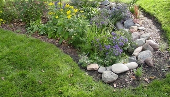
Rain gardens are an example of green infrastructure
Knowing where green infrastructure exists and how it is performing allows municipalities and stormwater practitioners to conduct targeted assessments and maintenance. Maintaining infrastructure is essential to achieving its full benefits, and understanding the state of green infrastructure in our region is a key factor in effective stormwater management.
2. Quantify the benefits of green infrastructure.
Understanding the type, size, and design capacity of green infrastructure throughout the region allows researchers to calculate the cumulative or local stormwater management capacity and impact of these installations.
3. Strategically plan investments in new green infrastructure where it will have the greatest impact.
When used in conjunction with the Urban Flooding Baseline, stormwater practitioners can make data-driven decisions to strategically decide where to invest in new green infrastructure that will have the greatest impact, resulting in a significant reduction in non-overbank flooding.
4. Advance training programs and best management practices to bolster implementation and maintenance of green infrastructure.
Seeing the quantity and dispersal of installations is crucial to encouraging participation in green infrastructure maintenance training programs and motivating private companies to add this skill to their list of services offered.
5. Use in conjunction with baseline understanding of municipal capacity in stormwater management.
Knowing the dispersal of green infrastructure in our region helps direct efforts to train municipal staff on the benefits and maintenance requirements for green infrastructure and highlights opportunities for service sharing or joint procurement of green infrastructure maintenance services.
For more information about this initiative: